Take in all the Sights
Discover
the Best Camping in California
More than 500 of the very best campgrounds throughout California
Sonora Pass Vacations
HOME
Lodging and Camping
Recreation Areas
- Clark Fork
- Dardanelle
- Dodge Ridge
- Kennedy Meadows
- Leavitt Meadow
- Leland Snowplay
- Mi-Wuk Village
- Pinecrest Lake
- Strawberry
- Twain Harte
- Wilderness Areas
Current Conditions
Outdoor Recreation
- Backpacking
- Bicycling
- Boating
- Day Hiking
- Fishing
- Golf
- Horseback Riding
- Miniature Golf
- Mountain Biking
- OHV
- Picnicking
- Swimming
Sightseeing:
Events
Services
- Emergency Services
- Church Services
- Forest Service
- Pack Stations/Riding Stables
- Restaurants
- Stores and Gas
Winter Activities
Geologic Wonders
From Giants to Gargoyles
Columns of the Giants
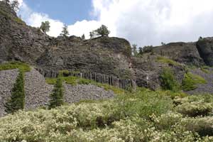
One of the most interesting of the natural wonders of Sonora Pass is the Columns of the Giants Trail located next to the Pigeon Flat Campground about 1.5 miles east of Dardanelle Resort. The trail provides an easy quarter mile walk to an unusual geologic formation with views of basalt columns, reminiscent of the Devil's Postpile. The Columns of the Giants are columnar hexagonal basalt rocks polished during ice ages. The Columns of the Giants were created when molten lava flowed into an ancient riverbed and collected behind a natural dam. As it cooled, it hardened and shrank, splitting into multi-sided, vertical columns. The parking and picnic areas were renovated in 2011.
Trail of the Gargoyles
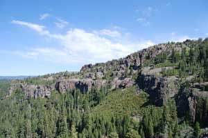
Another of the natural wonders of Sonora Pass is found by taking the 1.5-mile trail to strangely shaped volcanic rock formations which the Stanislaus National Forest calls Trail of the Gargoyles. You can pick up a pamphlet describing the trail at the Summit Ranger Station at the Y near Pinecrest. To reach the Trail of the Gargoyles drive east from Strawberry to the Herring Creek Road turnoff on your right. Follow it 6 miles (the last few miles are on dirt road) to an unmarked, dirt road turnoff to the left. A sign says No Camping Beyond This Point. Follow that short, slightly bumpy road to the edge of the canyon.
Trails leading off in either direction along the rim of the canyon offer spectacular views of a canyon walls and mountains in the distance. The trails do not form a loop. All along the cliff's edge are wondrous formations of volcanic rock that has eroded into strange shapes. Among the features are an ancient river bed, granite erratics (boulders left behind by the retreating ice), basalt columns, and the Wall of Noses.
Caution should be used because the crumbling cliff's edge could be dangerous to approach.
David Alt's Roadside Geology series has long been the best guides available for anyone interested in learning more about California's geology. This updated version, written with Donald W. Hyndman, has expanded coverage along with new photos and maps. In includes Lake Tahoe, Yosemite National Park, Lassen Volcanic National Park, Lava Beds National Monument, Kings Canyon National Park, and much more.
TOP
Ancient Trees
Bennett Juniper
Amon the the most well-known of the natural wonders of Sonora Pass is the 3,000-year-old Bennett Juniper, the largest western juniper in existence. The Bennett Juniper is at 8,400 feet elevation in Eagle Meadow. Drive east about 14 miles from Strawberry and turn right onto the Eagle Meadow Road. Usually the road is open by mid-June and remains open through October. There are two significant creek crossings (Eagle and Long Valley) that might be difficult for vehicles without high clearance early in the season. Usually by August the creeks are low enough for most vehicles to cross. It is a 13-mile drive from Highway 108, but it takes about an hour to drive.
The Bennett Juniper has a diameter of 13 feet and a height of 86 feet. Its branches are twisted and gnarled, making it a great subject for photography.
Trail of the Survivors
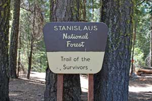
The Trail of the Survivors is a short loop with interpretive signs explaining how the trees of the forest have survived through fires and other hardships. To find the trail from Pinecrest, drive up the Dodge Ridge Road a short distance to the turnoff to the right to Camp Gold. Immediately after turning onto the road look for the sign marking the beginning of the trail on your left.
Trail of the Ancient Dwarfs
The Trail of the Ancient Dwarfs is a half-mile walk through a forest of ancient dwarf trees. A visit to the Trail of the Ancient Dwarfs is best coupled with a view of the ancient Bennett Juniper as they are both near Eagle Meadow. Drive about 15 miles east of Pinecrest on Hwy. 108 to Eagle Meadow Road on your right. Stay left when Eagle Meadow Road forks to the right. Follow Forest Service Road 5N24 past Niagara Creek Campground and park in turnoff near road-blocked bridge. The parking area is seven-tenths of a mile from Highway 108. Brochures are available in the trail register box. At an elevation of 6,600 feet, the half-mile trail overlooks the Middle Fork of the Stanislaus River Canyon and hikers even get glimpses of Highway 108 below. Part of the trail follows the historic Sonora and Mono Wagon Road.
TOP
TOP, Geologic Wonders, Ancient Trees, Waterfalls
Scenic Overlooks
Listed from west to east
Dodge Ridge Overlook
This unofficial overlook is known well to locals as a wonderful place to watch the sunset. From a high, clear point on Dodge Ridge, near the Aspen Meadow Pack Station and only a few miles from Pinecrest, the overlook affords a panoramic view to the west. Prominent in the distance is the deep Stanislaus River Canyon. On evenings with scattered clouds the sunsets are spectacular.
To reach the Dodge Ridge Overlook, drive up the Crabtree Road (either from near Cold Springs or by going up the Dodge Ridge Road out of Pinecrest and using the cross-over road just before the ski resort). Follow the Crabtree Road up to the top of the hill (4.8 miles from Pinecrest). Take the first dirt road on your right (before the pack station) and follow it up 100 yards to a flat turn-around/parking area.
Stanislaus River Canyon Overlook
Although not an official scenic viewpoint, the small turnout 2 miles east of Strawberry on the north side of Highway 108 offers a broad vista of the Stanislaus River Canyon. Directly below, although probably out of sight from most vantage points, rests Beardsley Reservoir. In the distance to the northwest is Big Trees State Park.
Donnell Vista
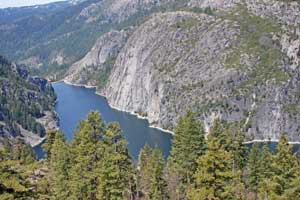
Open: After recent renovations, Donnel Vista re-opened July 18, 2011.
Donnell Vista overlooks Donnell Reservoir, a spectacular lake set in a deep canyon with
steep granite walls. The Donnell Vista is located on Highway 108
approximately 45 miles east of Sonora. A short trail leads down to a railed viewing
area which provides views of the reservoir, the Dardanelles Cones,
and the Middle Fork of the Stanislaus River. Restrooms are also located here.
An interpretive sign recalls a Gold Rush-era skirmish between Indians and workers for the Columbia and Stanislaus River Water Company. Miners constructed a ditch from what was then called Donnell Flat to Columbia to provide water for mining operations.
Que de Porka Overlook
One mile east of the Kennedy Meadows turnoff on Highway 108 is Que de Porka, a narrow divide in the rock where the road slips through. Immediately on the other side is a turnout. From this vantage point you can look southwest past Relief Reservoir at up to the Emigrant Wilderness. Snow often lingers on the peaks into the summer. It was through this area that the 1852-1854 emigrants brought their wagons along the Walker River Emigrant Trail on their way to Sonora.
Deadman Creek Overlook
A similar view to the Que de Porka overlook can be appreciated from a more developed overlook a mile farther east on the road where there is better parking and the Forest Service has installed interpretive signs.
Sonora and Mono Road Turnout
Five miles east of the Kennedy Meadows road on Highway 108 is a paved turnout along the side of Deadman Creek. Across the creek can be seen remnants of the old Sonora and Mono Wagon Road, opening in 1864.
Sonora Pass Summit
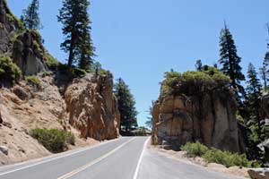
The top of Sonora Pass provides spectacular views eastward into Mono County and back across the crest of the Sierra. Just before you reach the summit of Sonora Pass there is a turnoff to picnic area with vault restrooms. You can park there to explore the summit of Sonora Pass, or you can find ample parking along the shoulder of the road right at the top of the pass. Signs there tell of the pass's discovery. The Pacific Crest Trail crosses Highway 108 there. Walks in either direction offer views of the surrounding country.
Leavitt Meadow Overview
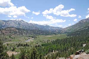
The unofficial Leavitt Meadow overview point is a wonderful place to look out across Leavitt Meadow and up toward the high Sierra. Magnificent Tower Peak on the northeastern boundary of Yosemite National Park rises on the skyline. The parking area is 6 miles east of Sonora Pass, just before you make an obvious hairpin turn to begin the final descent to Leavitt Meadow.
During the 1850s emigrants brought their wagons into the upper end of Leavitt Meadow from near Poore Lake and then forged a difficult trail up a narrow canyon at head of the meadow. Their route eventually led them north of Tower Peak and down the canyons and ridges to Dodge Ridge and Pinecrest.
TOP
TOP, Geologic Wonders, Scenic Overlooks, Scenic Overlooks
Waterfalls
Listed from west to east
Crystal Falls
Crystal Falls are located on Sullivan Creek downstream from Twain Harte. To view the falls take Phoenix Lake Road a few miles east of Sonora and follow it up almost 6 miles. Turn right onto Glenwood Road and then to Crystal Falls Drive.
Niagara Creek Falls
Niagara Creek Falls is relatively unknown in Tuolumne County because it is so difficult to reach a good viewing point. It is on Niagara Creek as it spills into Donnell Reservoir. The falls drops a spectacular 700 feet in a series of falls. To view it, park in a little turnout .3 miles west of the Donnell Overlook.
Follow a use-trail down the embankment until you are on a relatively flat bench (200 feet from car). Turn left and work your way along this bench (up and down) until you reach a view point where you can see the falls. It's about 200 yards. This is not a dangerous cross-country route, but there are high cliffs nearby. It's not a place for small children nor anyone not sure-footed. Another, more difficult to reach, view point would be from Donnell Lake.
The construction crews of the Sonora and Mono Wagon Road from the 1860s used to come out from their work camp in the evenings and sit on a rock near this point and view Niagara Creek Falls.
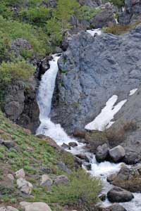
Brannock Falls
Brannock Falls is the first of a series of falls along the upper region of the Sonora Pass Highway. After driving 2.5 miles up the pass from the Kennedy Meadows turnoff, find a safe place to park along the side of the road. From the shoulder of the road look across Deadman Creek Canyon to the streams cascading into the canyon. At the bottom of the first of these is Brannock Falls, a 40-foot plunge. It is especially impressive in the spring.
Brannock Falls were named for Lyman H. Brannock, a road commissioner from the early 1860s who was the first to propose bringing the Sonora and Mono Wagon Road up the Deadman Creek Canyon rather than up the Clark Fork. At first Brannock was derided by his fellow road commissioners, but after further explorations they had to concede that Deadman Creek was the best route for the road.
Deadman Creek Falls
Located on the west side of Sonora Pass, 25-foot Deadman Creek Falls is on your left as you are headed up the pass. It's about a half mile before Blue Canyon Falls. Deadman Creek was originally called Rattlesnake Creek and then the North Branch of the Middle Fork of the Stanislaus River. In the mid-1860s a winter traveler ignored warnings about blizzard conditions on the pass and set out on foot. His frozen body was found a few days later along the side of the creek. The stream has been known as Deadman Creek ever since.
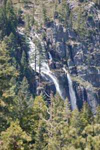
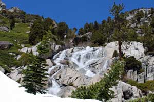
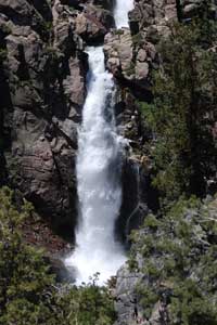
Blue Canyon Falls (shown right)
Located on the west side of Sonora Pass 6 miles past the turnoff to Kennedy Meadows, this 25-foot waterfall appears on your right as you are headed up the pass. Look for Blue Canyon Falls spilling down the black volcanic rock.
Several small lakes are hidden from view in the canyons above the falls. A string of high summits loom above, the highest of them, 11,500-foot Leavitt Peak.
On the opposite side of the highway here, look for a gully leading up to the ridge above the road. There you will see stonework from the original Sonora and Mono Wagon Road as it veered up from the canyon. The rounded ridge was known to early teamsters as the Hog's Back. As you drive up the pass, watch on your left for sections of stone embankments from the early road.
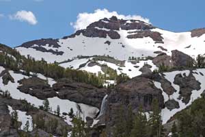
Sardine Creek Falls
40-foot high Sardine Creek Falls are located on the east side of Sonora Pass near the summit of the pass. As soon as you cross the pass heading east, look to your right (south) for the falls. Another cascade can be seen to the right of Sardine Creek Falls. Both usually dry up by late summer. The unnamed summit above Sardine Creek Falls rises nearly to 11,00 feet.
You could make a short hike out to a point above Sardine Creek Falls by taking the Pacific Crest Trail south from the top of Sonora Pass. It's only about a half mile walk, best done when snow has left the trail.
Sardine Falls
Sardine Falls are on the east side of Sonora Pass at Sardine Meadow. As you are headed east it is on your right, some distance away but easy to spot. It is actually two falls, an upper fall of 50 feet and a lower one at 20 feet.
Sardine Falls are on McKay Creek. The Pacific Crest Trail traverses the ridge high above the falls, passing from Sonora Pass south toward Yosemite. Although there is no established trail, you can hike cross-country to the base of Sardine Falls. Park along the road at the lower end of the meadow, thus avoiding the bushes. A trail to Leavitt Lake begins there, but you want to aim for Sardine Falls. It's about a 1.5 mile hike.
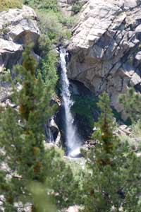
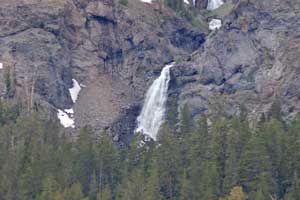
Leavitt Falls
Leavitt Falls are 6 miles down the east side of Sonora Pass on the mountainside overlooking Leavitt Meadow. Watch for a sign (set back from the road and hard to spot) indicating the falls and turn onto a little dirt road there to park. A short trail leads down to an overlook platform with spectacular views of the falls. Leavitt Falls drops about 250 feet in several steps.
Besides the falls, the overlook affords great views of Leavitt Meadow below. There are several picnic tables at the site, making it a nice place to stop for a break. Vault toilets are provided.
Silver Falls
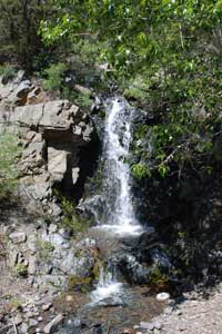
Silver Falls are on the east side of Sonora Pass between Leavitt Meadow and Poore Meadow. Look for it on your left if you are driving east. It makes about a 20 foot drop in two tiers. By late summer it usually dries up.
Silver Falls is on Cloudburst Creek, while Silver Creek itself plunges down from the heights a little bit farther to the east from Cloudburst creek.
While in the area, you might cross the road and glance down at a section of the old Sonora and Mono wagon Road that passed through Leavitt Meadow. The original survey for the road at Leavitt Meadow included a broad meander that crossed the Walker River several times, stirring loud complaints that the road commissioners from Mono County had guided the road past their ranches rather than along the most economical and straightforward route.
TOP