Sonora Pass
Historic Sites
Emigrant Trail
Gold Rush Mining Ditches
Relief Reservoir Dam
Early Wagon Road
Williams Ranch
Confidence Mine
Excelsior Hotel
Old Strawberry
Leland Meadow
Early Bridges
Eureka Valley
Douglas Station
Baker Station
Sonora Pass
Leavitt Meadow
Old 19th Century Cabins
Discover
the Best Camping in California
More than 500 of the very best campgrounds throughout California
Sonora Pass Vacations
HOME
Lodging and Camping
Recreation Areas
- Clark Fork
- Dardanelle
- Dodge Ridge
- Kennedy Meadows
- Leavitt Meadow
- Leland Snowplay
- Mi-Wuk Village
- Pinecrest Lake
- Strawberry
- Twain Harte
- Wilderness Areas
Current Conditions
Outdoor Recreation
- Backpacking
- Bicycling
- Boating
- Day Hiking
- Fishing
- Golf
- Horseback Riding
- Miniature Golf
- Mountain Biking
- OHV
- Picnicking
- Swimming
Sightseeing:
Events
Services
- Emergency Services
- Church Services
- Forest Service
- Pack Stations/Riding Stables
- Restaurants
- Stores and Gas
Winter Activities
Footprints of the Early Pioneers
The Walker River Emigrant Trail
Among the most interesting of Sonora Pass Historic Sites are the emigrant trails. The Walker River Emigrant Trail was opened in 1852 and used by emigrant wagon trains until 1854. It diverged from the main California Trail at Fort Churchill on the Carson River in Nevada and swept south to the Walker River, following it to its headwaters at the summit of the Sierra Nevada. The trail passed through today's Emigrant Wilderness, emerging at Dodge Ridge and then following roughly the route of Highway 108 to Sonora. Few remnants of the trail remain, but there are places you can view its route.
Pickel and Leavitt Meadows
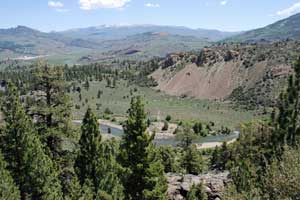
The Walker River Emigrant Trail descended the slope behind the Marine Mountain Warfare Training Center at Pickel Meadow, crossed the Walker River and headed up Pickel Meadow to Poore Lake. From there it crossed the ridge to the upper end of Leavitt Meadow before turning southwest into the high mountains.
Burst Rock
You can drive out the long, gravel road to Gianelli's Cabin and then hike a mile to the summit of Burst Rock. The emigrant wagons came up the back side of Burst Rock and down the ridges toward Dodge Ridge. Several babies were born to the emigrants near Burst Rock, prompting some to call it Birth Rock. One emigrant child arrived in the middle of a snow storm.
Camp Blue
In 1853 when emigrants reached the area around today's Camp Blue (near Pinecrest) they found a small farm house called the Strawberry Flat Ranch established by Samuel Wood. There the destitute pioneers could purchase fresh vegetables and hay for their stock. The emigrant trail angled up from Camp Blue to the ridge north of Highway 108 and followed the ridge top down through today's Pinecrest School, past Long Barn. At Sugarpine it cut off along the route of today's Middle Camp Road down through Twain Harte.
TOP
Gold Rush Era Miners' Ditches and Reservoirs
During the Gold Rush miners desperately needed water in Sonora and Columbia. The Tuolumne County Water Company built a ditch up to the site of today's Lyons Reservoir where they constructed a dam to divert water into the ditch. Other ditches were run to the North Fork of the Tuolumne River near Long Barn.
The Columbia and Stanislaus River Water Company constructed an ambitious ditch that ran from above today's Donnell Reservoir, down the Middle Fork of the Stanislaus, through a tunnel near Spring Gap, and then down the South Fork of the Stanislaus.
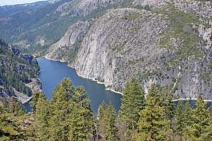
Strawberry Lake (Pinecrest Lake) and several reservoirs upstream from Strawberry Lake were built to enhance the summer water supply through the ditches.
Ditches Still in Use
Many miles of the early ditches and flumes are still in use today. They can be seen flowing serenely through neighborhoods in Twain Harte and Confidence. The best place to see a flume is at Lyons Dam. Take the Lyons Dam Road off Highway 108 (just east of Sierra Village) to the parking area by the reservoir and walk down the road to the dam. A trail with railings leads down to the foot of the dam where you can see the flume winding away along the side of the canyon, much the way it appeared in the 1850s.
Remnants of Old Gold Mining Era Reservoirs
If you hike upstream from the eastern end of Pinecrest Lake you will soon come to the remnants crib dam that held back the waters of Big Dam Reservoir. Middle Dam was located, naturally, between the other two reservoirs. There is no established trail to follow, however.
TOP
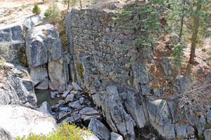
Relief Reservoir Dam
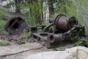
Relief Reservoir was built during the early 20th century. A road was carved out of the mountainside leading from Kennedy Meadows up the canyon to the site of the dam. Equipment was dragged up this steep route using steam donkeys and winches. Today remnants of the machinery used in the construction of the dam can be found scattered along the trailside. Near the dam the old blasting powder storage vault remains built into the side of the mountain.
During the construction of the dam a small community of cabins for the workers was erected on the south slope of the mountain. Nothing remains of the settlement today. Proposals were made to build another dam in Kennedy Canyon and flood the entire valley, including Kennedy Lake; but the project never left the drawing table.
TOP
The Sonora and Mono Wagon Road
The Sonora and Mono Wagon Road was constructed in 1863-1864 to connect Tuolumne County with the mining districts on the eastern side of the Sierra, particularly Esmeralda, Nevada, and scattered strikes in Mono County. Remnants of the old wagon road abound along Highway 108, although they are sometimes difficult to recognize. The best sections to view are at the higher elevations on the western slope of Sonora Pass.
Cow Creek to Niagara Creek
Cow Creek Road follows the route of the early wagon road. At one time a ranger station stood there at Cow creek. At Niagara Creek the old road followed the campground road across the creek and then along the side of the mountain several hundred yards above the modern highway.
One of the most interesting sections of the old road is the rockwork embankment built up just beyond Niagara Creek. If you drive on Highway 108 one quarter mile east past the Niagara Creek bridge and then turn up a dirt road on your right, you will soon find a good example of the old road.
The Patterson Grade
Construction foreman John Danforth Patterson supervised the building of the steep grade from today's Donnell Vista down to the Clark Fork. Just a third of a mile east of the Vista a dirt road angles away from the highway. You can park there and walk down the old Patterson Grade that used to strike fear into many early motorists. Boulders and bushes have made passage difficult in places.
Deadman Creek
One mile past Chipmunk Flat is perhaps the best place to view the old wagon road. A long turnout beside the highway marks the spot. The Forest Service used to maintain signs there about the Sonora and Mono Wagon Road. From the turnout you can see long stretches of the road on the hillside across the creek.
Near the Summit of Sonora Pass
Beyond the hairpin turn just above the last mentioned turnout, begin to watch for remnants of the rock embankment of the old road on your left.
TOP
Williams Ranch - Twain Harte
Among the earliest settlers in the Twain Harte area was the Calvin J. Williams family. Calvin, his wife Ann and four children crossed the emigrant trail over Sonora Pass by wagon in 1853. In 1854 Calvin claimed land along upper Sullivan Creek and gradually expanded his holdings to include what was known as the Bald Rock Ranch. Today Bald Rock pokes up out of Twain Harte Lake. A few old farm houses from the 19th century can still be seen about the Twain Harte area.
TOP
Confidence Mine
The Confidence Mine, located just across Highway 108 from the Confidence Inn, was first discovered in 1856, but it wasn't until the 1860s that the extent of the gold strike was appreciated and quartz mining began in earnest. An incline shafts 1000 feet deep was excavated, and 2000 of tunnels were extended underground. Millions of dollars in gold were extracted from the mine. Other mines nearby made Confidence a booming mining region in the 1860s.
TOP
Excelsior Hotel
The Excelsior Hotel in Sugarpine was a popular gathering place for travelers and campers in the latter half of the 19th century. Established by Thomas J. Northrup in the 1860s, the hotel stood for years at the side of the wagon road. A historical marker in Sugarpine near the fire station indicates the general location of the hotel.
TOP
Strawberry
Strawberry was a popular mountain retreat during the 19th century. Residents of lower elevations
flocked to Strawberry during the summer months to escape the hear, to hunt and fish, and to enjoy
the companionship of camping together in large groups. John McDonald may have operated the first resort at Strawberry, but he soon sold
it to James Allen. Ed Parsons and his wife became the proprietors in 1886 and developed the resort as
the premier retreat on Sonora Pass for decades to follow. The resort was owned by the Conlin family during the
first half of the 20th century. The two-story resort burned in the 1940s.
See also Strawberry.
TOP
Leland Meadow
Leland Meadow was claimed as pasture land by Gustavus Adolphus Leland, a baker and farmer from Jamestown, and his wife Frances. Gustavus and Frances raised eight children in Jamestown. Some old farm buildings still stand at the meadow that bears their name. Today the area has been turned into a winter snow play area. See Leland High Sierra Snowplay.
TOP
Stanislaus River Bridges
The 1933 Bridge
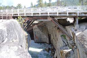
The old 1933 bridge across the Stanislaus River has been designated a historic site since it was replaced by a new bridge constructed next to it. The best spot to park to visit the bridge is on the east side. A short stairway leads down to a viewing platform beneath the old bridge. There you can see the underpinnings of the bridge and the Stanislaus River plunging through a narrow gorge in the rock. The Middle Fork Stanislaus River Bridge, also known as the Dardanelle Bridge, represents the last known timber scissors truss, a bridge type well suited for quick erection in rugged locations without the use of falsework. The bridge was determined eligible for inclusion in the National Register of Historic Places in 1987.
The 1864 Bridge
Seemingly overlooked by those who placed the 1933 bridge on the historic register are the bridge abutments for the original bridge to span the Stanislaus at this location. The original bridge was constructed 69 years earlier than its 1933 replacement. Workers for the Sonora and Mono Wagon Road in 1864 constructed the stone abutments and then spanned the river with massive logs. The stonework is still standing today and visible just a hundred yards upstream from the highway.
TOP
Eureka Valley
In Eureka Valley, .5 miles east of the Eureka Valley Campground, a plaque commemorates the road house established by David Hayes and Jack Welch in 1864-1865 during the boom days of the Sonora and Mono Wagon Road. The building stood in the clearing and served as a stopping place for travelers. The building was constructed from hewn logs with mortised corners. Hayes and friends were known to winter there on occasion.
TOP
Douglas Station
The old Douglas Resort once occupied the land across the road from the Douglas Picnic Area. The resort was built in the 1920s. The main building contained a dining room and kitchen. Guests slept in tents, which rented for $1 a day. Scenes for the old movie Robin Hood of El Dorado were filmed near the resort.
TOP
Baker Station
In the 1880s Greenbury C. Baker from Sonora opened what he described as a "Summer Resort" at Baker's Station, just a half mile back down the highway from the Kennedy Meadows turnoff. Baker offered accommodations to individuals or families for a day, a week, or a month. The hostelry was used mostly by people crossing the pass on the wagon road.
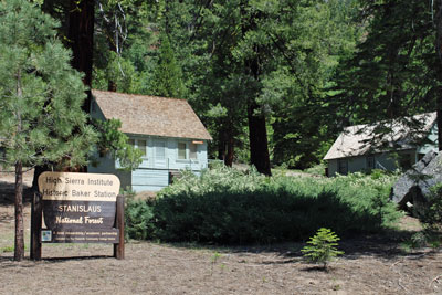
By 1890 snow had collapsed the original buildings. Later the site was turned into a highway maintenance station. Today Baker's Station is used by the High Sierra Institute in partnership with Yosemite Community College. The Institute has hosted classes such as cartography, geology, yoga, and creative writing. Recent work has upgraded several of the cabins and the restrooms.
TOP
Sonora Pass
At the top of Sonora Pass is a marker attributing the discovery of the pass to Andrew Fletcher. Fletcher was the superintendent of the Columbia and Stanislaus River Water Company and the owner of a sawmill in Sugar Pine. According to the account, Fletcher and a companion, Joseph Spier, discovered the pass while on a fishing and hunting outing in 1862.
TOPLeavitt Meadow Hostelry
In the 1860s when the wagon road first opened, Hiram Leavitt brought his family over Sonora Pass and established a small hotel on the bank of the river in Leavitt Meadow. A marker notes the historic site, but there is virtually nothing to be seen there. Eventually Leavitt tired of running the way station and moved his family to Bridgeport.
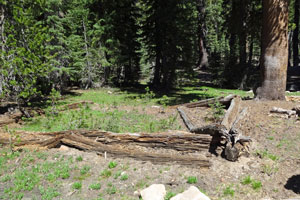
TOPOld 19th Century Cabins
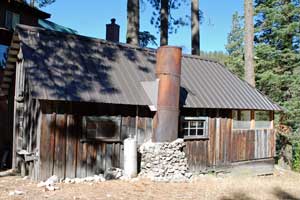
A number of old log cabins and wooden structures scattered about the back country have survived. Most were built by ranchers to use as outposts (Cow Camps) for the ranch hands who tended cattle on mountain ranges during the summer. Driving stock to the high country in the summer was a common practice even into the mid-20th century. Other cabins were hunting and fishing shelters. Most require several hours of hiking to reach, but a few stand in meadows at the ends of Forest Service roads.
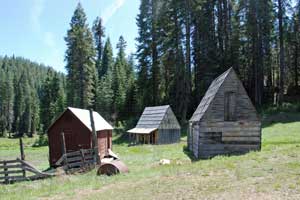
- Cooper Meadows - These early cabins can be seen by driving to Coyote Meadow off Herring Creek Road and then hiking 3.5 miles to Cooper Meadow.
- Fahey Cabins - (shown left) Located on Wrights Creek along Forest Service road 3N07, off the North Fork Road, 5 miles east of Long Barn. Others buildings are farther out these roads. The Faheys were early cattlemen in the area.
Gianelli Cabin - The remnants of the Gianelli cabin are in a small meadow 12 miles east of Pinecrest off the Crabtree Road. The cabin was constructed by A. G. Gianelli, probably Antone Gianelli, in the early 1900s and used as a hunting outpost. Antone was a farmer and rancher living in the Summersville area. Antone, or Antonio as he was also called, was born in Italy and came to the United State in the 1860s. He and his wife Lilly raised five children.
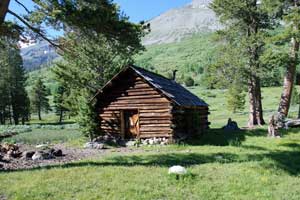
Kennedy Lake Cabins - A rustic log cabin (shown left) is situated near Kennedy Lake in the Emigrant Wilderness, a full 6-mile hike from Kennedy Meadows. The Kennedy family from Knights Ferry grazed cattle in the mountains in the late 19th century.
TOP