The Clark Fork Recreation Area
Fishing, Horseback Riding, Camping
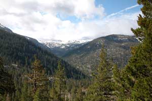
The Clark Fork Road leaves Highway 108, the Sonora Pass Highway, 46 miles east of Sonora at an elevation of 5,600 feet, leading into the Clark Fork Recreation Area. The road parallels the Clark Fork for 9 miles before ending at Iceberg Meadow at the edge of the Carson-Iceberg Wilderness at an elevation of 6,100 feet.
Three National Forest campgrounds, a picnic area, and several private camps are located along the road. A fourth campground is located just outside the Clark Fork drainage at Fence Creek. The campgrounds are usually open from the beginning of fishing season in late April until the end of October.
The 2018 Donnell Fire burned much of the forest along the Clark Fork. However, the campgrounds were saved. Trails along the Clark Fork beyond Iceberg Meadow were spared.
Fishing and Hiking on the Clark Fork
Fishing
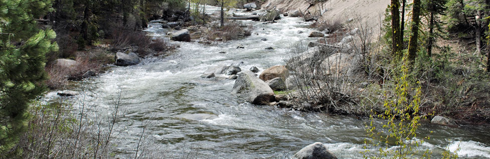
The Clark Fork is well known for its great fishing. Easy access to the river can be found in many places along the 9 miles of the Clark Fork Road. Some of the best fishing holes are in places where the road veers away from the river. A short hike can take you to those less often fished spots.
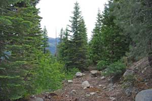
Leading away from Iceberg Meadow, a trail parallels the Clark Fork for miles. The first several miles of the river above Iceberg Meadow offer good fishing in pockets and riffles.
For more information about fishing on the Clark Fork visit Dave's Sierra Fishing at Clark Fork Fishing.
Shop Amazon:
Trout Fishing Best Sellers
Trout Fishing Best Sellers
Hiking
Upper Clark Fork and St. Mary's Pass
A number of good trails lead out of the Clark Fork area. Only the trail following the river upstream out of Iceberg Meadow could be classified as fairly easy. It passes through shaded forest while almost always within earshot of the river. For the first two miles it climbs at a gentle grade, gaining only 500 feet. From there the trail continues up the Clark Fork for another 7 miles to Saint Mary's Pass, climbing nearly 3,000 feet. The trail to Boulder Lake diverges from the Clark Fork trail after two miles and climbs another two miles to the secluded lake.

The Disaster Creek trail leads north out of Iceberg Meadow, following the tumbling water of Disaster Creek. Several meadows along the way make good turn-around points. Ambitious hikers could push all the way up to Highland Lakes off the Ebbetts Pass highway, a 7.5-mile, 2000-foot climb.
The Arnot Creek trail begins at a trailhead near Camp Liahona. One spur of the trail leads up under the shadow of the Dardanelles and eventually on to Spicer Meadow Reservoir, 8 miles in distance. Another spur of the trail follows Arnot Creek up to its headwaters and eventually ending at Highland Lakes (8 miles).
TOP
Clark Fork Campgrounds
Clark Fork Campground
The Clark Fork Campground is 6 miles from the turnoff on Highway 108, close to many recreation opportunities. The large campground is divided into two loops (A and B). Loop A has 28 sites with piped water and pit toilets. Loop B has flush toilets and 60 sites. Each site is $26 per night. A RV dump station is located near the entrance to the campgrounds. The Clark Fork Campground is on a first-come, first-served basis.
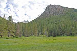
Iceberg Meadow
Clark Fork Horse Camp
The Clark Fork Horse Camp is situated next to the Clark Fork Campground (see above). As its name implies, this camp is reserved for campers with horses. The Forest Service in conjunction with Backcountry Horsemen of California Mid-Valley Unit operates Clark Fork Horse Camp and suggests a donation to cover the cost of maintaining the campground. There is no piped water. The facility has vault toilets. The campground is on a first-come, first-served basis. Horseback riders will find numerous recreation riding trails in the area.
Sand Flat Campground
Sand Flat Campground is 6.5 miles up the Clark Fork Road from Highway 108. It is situated along the bank of the Clark Fork with 15 walk-in type camp sites close to the river and 53 tent or RV sites. Each site costs $24 per night. Water comes from old fashion hand pumps. The campground has vault toilets. Sand Flat Campground is on a first-come, first-served basis. Campers will find recreation opportunities abound in the area. Evening campfires are popular at Sand Flat Campground.
Fence Creek Campground
The Fence Creek Campground is on a dirt road that splits off from the Clark Fork Road less than a mile from Highway 108. Once on the dirt road watch for the entrance to Fence Creek Campground soon on your right. It is at an elevation of 5,800'. The 38 camp sites have no piped water. The campground has vault toilets. The cost is $8 per night.
For more about the campgrounds, see Clark Fork Campgrounds