
Dardanelle - Brightman Flat Recreation Area
Fishing, Hiking, Bicycling, Campfires, Exploring
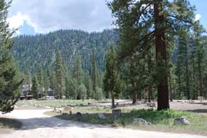
The Dardanelle - Brightman Flat Recreation Area of Sonora Pass's Highway 108 stretches 7 miles from the turnoff to the Clark Fork to Douglas Picnic Area, at elevations around 6,000 feet. The wide river valley is flanked by 9,000 to 10,000-foot peaks. This relatively level stretch of road along the Middle Fork of the Stanislaus River attracts many summer visitors because of its proximity to great fishing and hiking and because of its scenic beauty.
A series of excellent campgrounds are located along the Stanislaus River and a scattering of rustic summer vacation cabins are tucked away among the pines.
The area around Dardanelle and Brightman Flat was seriously impacted by the 2018 Donnell Fire. A number of structures were damaged or destroyed and large areas of the forest were burned. Since then, the area has made a remarkable comeback with roads and campgrounds reopened. Dardanelle Resort, which was heavily damanged by the fire, has remained closed.
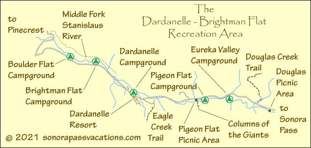
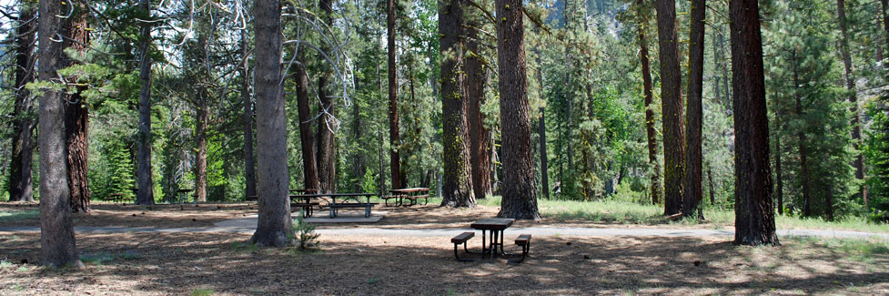
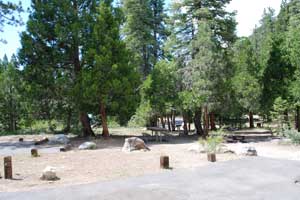
Douglas Picnic Area
The Douglas Picnic Area is 3.5 miles east of the Dardanelle Resort. It has a half dozen picnic tables scattered on a flat under the shade of mature pines. There are vault toilets provided.
A paved trail leads down to the Stanislaus River where a pair of benches are set with nice views of the river. The benches were erected in memory of Bradford York who used to do living history presentations for the Stanislaus National Forest.
Columns of the Giants Picnic Area
A picnic area is available adjacent to the parking lot at Columns of the Giants nature trail. Vault toilets are provided. The site is away from the highway among the trees.
Columns of the Giants
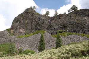
The Columns of the Giants Trail is located next to the Pigeon Flat Campground about 1.5 miles east of Dardanelles Resort. The trail provides an easy quarter mile walk to an unusual geologic formation with spectacular views of basalt columns, reminiscent of the Devil's Postpile.
The Columns of the Giants are columnar hexagonal basalt rocks polished during ice ages. The Columns of the Giants were created when molten lava flowed into an ancient riverbed and collected behind a natural dam. As it cooled, it hardened and shrank, splitting into multi-sided, vertical columns.
David Alt's Roadside Geology series have long been the best guides available for anyone interested in learning more about California's geology. This updated version, written with Donald W. Hyndman, has expanded coverage along with new photos and maps. In includes Lake Tahoe, Yosemite National Park, Lassen Volcanic National Park, Lava Beds National Monument, Kings Canyon National Park, and much more.
Fishing
Fishing is good all along the Middle Fork of the Stanislaus River for rainbow, brook, and brown trout. Fishing is usually best beginning in mid-summer when the heavy spring runoff has settled down.
Shop Amazon:
Trout Fishing Best Sellers
Trout Fishing Best Sellers
Hiking
The best hiking around Dardanelle and Brightman Flat is probably along the length of the valley. There are no established trails connecting the various campgrounds, but short jaunts along the shoulder of the road can get you from one meadow area to another. A dirt road can be picked up from the Clark Fork Road just on the other side of the bridge. The road leads up the north side of the Stanislaus River.
Two trails lead up the mountainsides from the Dardanelle - Brightman Flat area, one up Douglas Creek on the north side of the valley and the other up Eagle Creek on the south side. The Douglas Creek trail begins at the end of a dirt road just east of Eureka Valley. The 5-mile trail climbs 3,500' to the summit of the mountains. It's a difficult uphill hike.
The Eagle Creek trail begins at the end of a dirt road between the Dardanelle Resort and Eagle Creek . The 4-mile hike climbs 1,500' and takes you to Martin's Cow Camp near Eagle Meadow. Most of the climbing is done in the first 1.5 miles.
TOP
Historic Sites
Stanislaus River Bridges
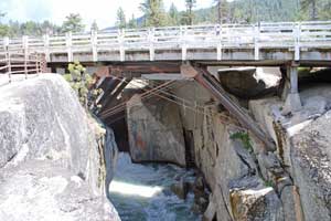
The old 1933 bridge across the Stanislaus River has been designated a historic site since it was replaced by a new bridge constructed next to it. The best spot to park to visit the bridge is on the east side. A short stairway leads down to a viewing platform beneath the old bridge. There you can see the underpinnings of the bridge and the Stanislaus River plunging through a narrow gorge in the rock. The Middle Fork Stanislaus River Bridge, also known as the Dardanelle Bridge, represents the last known timber scissors truss, a bridge type well suited for quick erection in rugged locations without the use of falsework. The bridge was determined eligible for inclusion in the National Register of Historic Places in 1987.
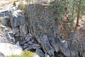
Seemingly overlooked by those who placed the 1933 bridge on the historic register are the bridge abutments for the original bridge to span the Stanislaus at this location. The original bridge was constructed 69 years earlier than its 1933 replacement. Workers for the Sonora and Mono Wagon Road in 1864 constructed the stone abutments and than spanned the river with massive logs. The stonework is still standing today and visible just a hundred yards upstream from the highway.
Eureka Valley
In Eureka Valley, ½-mile east of the Eureka Valley Campground, a plaque commemorates the road house established by David Hayes and Jack Welch in 1864-1865 during the boom days of the Sonora and Mono Wagon Road. The building stood in the clearing and served as a stopping place for travelers. The building was constructed from hewn logs with mortised corners. Hayes and friends were known to winter there on occasion.
Douglas Station
The old Douglas Resort once occupied the land across the road from the Douglas Picnic Area. The resort was built in the 1920s. The main building contained a dining room and kitchen. Guests slept in tents, which rented for $1 a day. Scenes for the old movie Robin Hood of El Dorado were filmed near the resort.
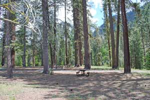
Campgrounds
Boulder Flat Campground
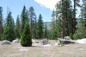
The Boulder Flat Campground is located on Highway 108 about 1.8 miles west of the Dardanelle Resort. The Middle Fork of the Stanislaus River runs past the campground. At an elevation of 5,600' Boulder Flat Campground is usually open from late May through October. It is on a first come, first served basis.
Fees: $22 for a single site and $5 for an extra vehicle
Boulder Flat Campground Amenities
- 3 tent-only sites and 17 RV or tent sites
- Piped water
- Vault toilets
Brightman Flat Campground
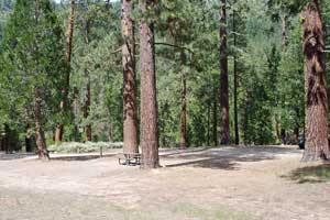
The Brightman Flat Campground is located on Highway 108 one mile west of the Dardanelle Resort. The Middle Fork of the Stanislaus River runs past the campground. At an elevation of 5,880' Brightman Flat Campground is usually open from late May through October. It is on a first come, first served basis.
Fees: $22 for a single site and $5 for an extra vehicle
Brightman Flat Campground Amenities
- 14 tent-only sites and 18 RV or tent sites
- Piped water
- Vault toilets
Dardanelle Campground
The Dardanelle Campground is located on Highway 108 across from the Dardanelle Resort. The Middle Fork of the Stanislaus River runs past the campground. At an elevation of 5,700' Dardanelle Campground is usually open from late May through October. It is on a first come, first served basis.
Fees: $25 for a single site, $50 for a double site, and $5 for an extra vehicle
Dardanelle Campground Amenities
- 6 tent-only sites and 21 RV or tent sites
- Piped water
- Vault toilets
Pigeon Flat Campground
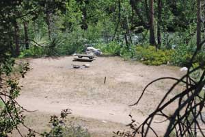
The Pigeon Flat Campground is located on Highway 108 1.5 miles east of the Dardanelle Resort. It is a "walk-in" campground, meaning that your vehicle is parked a short distance away from your camp site. It has no potable water. The Middle Fork of the Stanislaus River passes close to the campground. The Columns of the Giants, a geologic site, and Columns of the Giants Picnic Area are adjacent to the campground. At an elevation of 5,950' Pigeon Flat Campground is usually open from late May through October. It is on a first come, first served basis.
Fees: $15 for a single site and $5 for an extra vehicle
Pigeon Flat Campground Amenities
- 7 tent sites
- No piped water
- Vault toilets
Eureka Valley Campground
The Eureka Valley Campground is located on Highway 108 2.5 miles east of the Dardanelle Resort. The Middle Fork of the Stanislaus River loops past the campground. At an elevation of 6,100' Eureka Valley Campground is usually open from late May through October. It is on a first come, first served basis.
Fees: $24 for a single site and $5 for an extra vehicle
Eureka Valley Campground Amenities
- 27 RV or tent sites
- Piped water
- Vault toilets