Bicycling Index
Pinecrest Lake
Twain Harte
Sonora Pass
Clark Fork Road
Herring Creek Road
Old Strawberry Road
Pickel Meadow
Cycling on Ebbetts Pass
Discover
the Best Camping in California
More than 500 of the very best campgrounds throughout California
Sonora Pass Vacations
HOME
Lodging and Camping
Recreation Areas
- Clark Fork
- Dardanelle
- Dodge Ridge
- Kennedy Meadows
- Leavitt Meadow
- Leland Snowplay
- Mi-Wuk Village
- Pinecrest Lake
- Strawberry
- Twain Harte
- Wilderness Areas
Current Conditions
Outdoor Recreation
- Backpacking
- Bicycling
- Boating
- Day Hiking
- Fishing
- Golf
- Horseback Riding
- Miniature Golf
- Mountain Biking
- OHV
- Picnicking
- Swimming
Sightseeing:
Events
Services
- Emergency Services
- Church Services
- Forest Service
- Pack Stations/Riding Stables
- Restaurants
- Stores and Gas
Winter Activities
Pinecrest Lake Cycling
Bike Trails, Bicycle Rentals, Scenic Routes
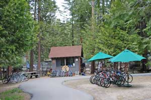
Bicycling on Sonora Pass roads and bike paths doesn't get much better than the area around Pinecrest Lake. In the summer bicycle rentals are available at Pinecrest Lake at the little shopping area there. They offer bicycles of several varieties, including children's bikes and mountain bikes. For $1 you can purchase a map of the area with bicycling routes for both road and mountain biking.
For casual bicycling, the little community of Pinecrest makes a good place to explore. Light traffic and few hills make for easy going. Also winding through the campgrounds can sometimes be fun. A paved walking-bicycle trail runs from Pinecrest Campground out through Meadowview Campground.
For experienced cyclists, consider the road up to Dodge Ridge. It sees little traffic in the summer. The 3.5-mile road climbs 1000 feet, making for a strenuous ascent. Several sharp curves deserve particular caution. (not suitable for children)
TOP
Cycling in Twain Harte
Twain Harte has good bicycling roads for the casual rider. There are enough hills to give you a solid workout if you choose, and it is always interesting to ride around vacation communities looking at the various cabins and other sights.
For experienced cyclists the 7 mile ride down to the town of Tuolumne passes through scenic countryside. The road drops about 1200 feet, making for a long climb back to town. Another route with plenty of hill work is the South Fork Road, 5 miles from Twain Harte to the Stanislaus River. The road climbs 500 feet out of Twain Harte and then drops 500 feet to the river. It's narrow and deserves coinsiderable caution.
TOP
Bicycling on Sonora Pass
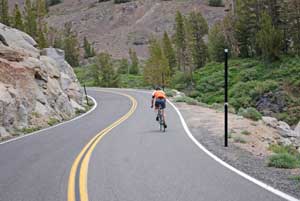
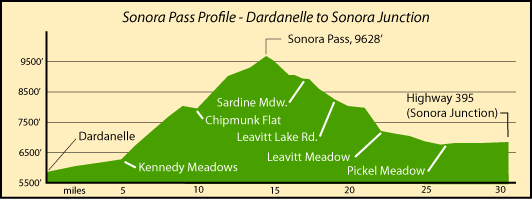
For serious road cyclers the trip over Sonora Pass can be a challenge. In places the grade reaches about 27%. Riders generally start out in the Dardanelles area early in the morning and push off for the pass with a supply of water and nourishment. The first five miles are generally level, giving your body a chance to warm to the task ahead of you.
Then in the next one mile the road climbs 1,000 feet in elevation. To the top of Sonora Pass from Dardanelles is 14.5 miles, with an exhausting 4,000' total gain in elevation. The road is narrow and with many blind turns, making safety an important consideration.
Some cyclers continue on over the east side of Sonora Pass, dropping 3,000' in 11 miles to Pickel Meadow and then turning around and going back the way they came. Others keep on going all the way out to Highway 395 at Sonora Junction, making it just over 30 miles from Dardanelle.
For an account of this cycling route and even more, see Chain Reaction.
The Complete Guide to Climbing (By Bike) in California (2010) covers the rides up both sides of Sonora Pass and other great summits in the area.
TOP
Cycling along the Clark Fork Road
The 11-mile Clark Fork Road is an enjoyable route with a mild grade, climbing only about 1,000' spread fairly evening along its length. Park near the bridge soon after turning onto the Clark Fork Road from Highway 108. Then ride up to the end of the road at Iceberg Meadow where you could rest and have a picnic before coasting back to your car.
TOP
Herring Creek Road Bicycle Routes
The 4 paved miles of the Herring Creek Road climbs about 1,000'. Traffic is generally light on the road and it passes through shaded forest at about the 6,000' elevation. You will find Herring Creek Road, the starting point of this ride, about 2.5 miles beyond Strawberry on Highway 108.
TOP
Cycling the Old Strawberry Road
The narrow, shaded Old Strawberry Road makes a nice bicycle ride. Start in Strawberry or at the upper end where the road joins Highway 108 a mile east of Cold Springs by the Pinecrest School. The 3-mile long road drops about 400' from Pinecrest School down to the Stanislaus River at Strawberry and then climbs a short grade to rejoin Highway 108.
TOP
Bicycle from Pickel Meadow to Sonora Junction
This easy 5-mile begins at a little turnout on Highway 108 at the west end of Pickel Meadow on the east side of Sonora Pass. From there you ride east on Highway 108, passing the Marine Mountain Warfare Training center. Off to your right will be the expanse of Pickel Meadow and the easy flowing West Walker River. In the distance you can see snow-clad Tower Peak. The route drops down to a bridge across the river and then begins a gentle climb to Sonora Junction. Highway 108 ends there as it meets Highway 395. You could continue your ride on 395, but it has a lot more traffic.
TOP
Cycling on Ebbetts Pass and Carson Pass
Ebbetts Pass
Ebbetts Pass to the north offers a whole new array of great cycling opportunities. The famous Tour of California Alps Death Ride® race includes Ebbetts Pass in its course. Other great cycling routes are found on the east side of the pass around Markleeville and on the west side at Bear Valley and Calaveras Big Trees State Park. To learn more, visit our sister website Ebbetts Pass Adventures.
Carson Pass
Farther north on Carson Pass (Highway 88) are miles of enjoyable cycling roads. The ride over Carson Pass is a classic as well as Blue Lakes Road through Hope Valley. For cycling destinations off Carson Pass, see Up and Over Carson Pass.